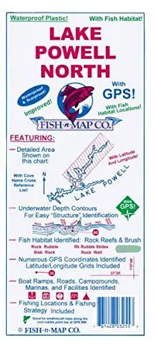
Description
- Features
- Contours: 20′ & 80′
- Scale: 1:48,000
- GPS Data: Yes
- Water Type: Fresh
- Region/State(s): Utah
- UPC: 761428 032553
- Notes
- Lake Powell North – Colorado River Inlet through Escalante Arm
- Waterproof, Tear-Resistant Plastic
- Folds to 9″ × 4″, Unfolded 3′ × 2′
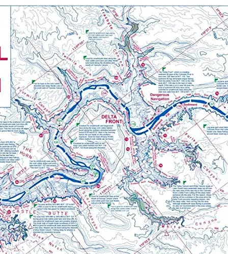
- Additions/Improvements to Fish-n-Map Company’s Lake Powell North map Updated February 2019
- Rocky fish habitat areas have been added which include the following rock types: Rock walls, solid rock, slab rock, rock rubble, and rock rubble slides
- Submerged brush fish habitat areas have been added
- Additional feeder cuts are shown
- Improved depth contours
- Updated the suggested fishing locations with an emphasis on the fish habitats in applicable areas
- Updated the fishing strategy with an emphasis on the fish habitat areas
- Sediment filled areas have been updated including the Colorado River inlet area, Bullfrog Bay, Halls Creek Bay, Red Canyon, Blue Notch Canyon, and more
- Updated facility information
- 2016 Updates:
- Improved depth contours by adding a 60′ contour and a 140′ contour
- Updated suggested fishing locations
- Added numerous feeder creek channels
- Features:
- Numerous Fishing Locations with GPS Coordinates Provided!
- Fishing Strategy Included
- Underwater Depth Contours for Easy Structure Identification Provided
- Boat Ramps, Roads, Campgrounds, Marinas, and Facilities Identified
- For Southern Area, See Fish-n-Map Company‘s Lake Powell South map
- Made in U.S.A.
Explore more from our collection.


![Ecuador, Quito, Guayaquil, Galapagos [Map] Pham Viet Hoa And Kevin Healey 1](https://carpartsvault.shop/wp-content/uploads/2026/05/41hS5ABEG-L._SL1000-lEpnia.tmp_.webp)
Reviews
There are no reviews yet.