
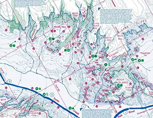
Description
- Features
- Contours: 10′
- Scale: 1:20,000
- GPS Data: Yes
- Water Type: Fresh
- Region/State(s): Arizona
- UPC: 761428 052094
- Notes
- Updated May 2019
- Additions and Improvements to Fish-n-Map Company’s Roosevelt Lake (Arizona) map UPC #761428 052094
- Added fish habitat including submerged brush up to 55′ deep, rock rubble reefs and artificial habitat structures
- All new 1-minute longitude and latitude grids which use a datum of NAD 83
- Redid outline of the lake at full pool and at 50′ down
- All new fishing strategy and fishing suggestions
- New GPS coordinates provided
- Facilities and Roads updated
- Added onshore brush and tree locations
- Added a third color (green) to map
- Features:
- 10-foot underwater depth contours for easy structure identification
- Numerous GPS coordinates identified
- Submerged brush and trees identified
- Includes fishing locations and fishing strategy
- Printed on a waterproof, tear-resistant material
- Map folds to 4″×9″, unfolds to 3’×2′
- Made in the U.S.A.
- Curtis Sporbert
Explore more from our collection.
![Estado De Baja California Sur [Map] Guia Roji 1](https://carpartsvault.shop/wp-content/uploads/2026/05/51NXwO-_2BFSL._SL1000-rHEoCx.tmp_.webp)
![Arizona's White Mountains [Map] Russel Mead 1](https://carpartsvault.shop/wp-content/uploads/2026/05/51Yr21jVcsL._SL1000-9RhxEj.tmp_.webp)

Reviews
There are no reviews yet.