Description
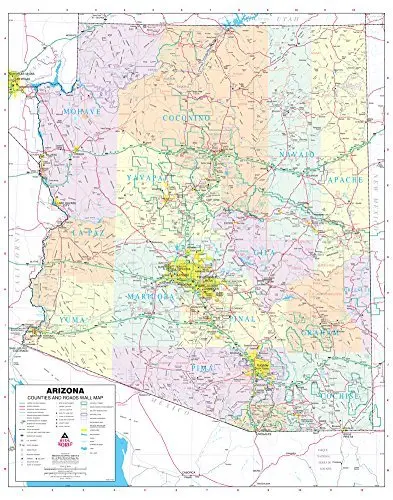
Phoenix Mapping Service‘s Arizona Counties and Roads Large Wall Map Dry Erase Laminated is a State of Arizona dry erase laminated color wall map detailing counties and roads in a large 47″ x 60″ size.
This detailed and up-to-date State of Arizona wall map defines counties with pastel coloring and is ready for dry erase markers. Also included are cities and towns with relevant population information; all of the interstate, state, and tribal highways systems; rivers, streams, and lakes; mountain ranges; tribal lands, military reservations, wilderness areas, and wildlife refuges; and National Parks, Forests, and Monuments.
Dry Erase Lamination is specialty laminate that allows for dry erase markers to be used on the finished print and erased as desired.
- Dry erase laminated, one-sided wall map.
Explore more from our collection.
![Estado De Baja California Sur [Map] Guia Roji 1](https://carpartsvault.shop/wp-content/uploads/2026/05/51NXwO-_2BFSL._SL1000-rHEoCx.tmp_.webp)


Reviews
There are no reviews yet.