Description
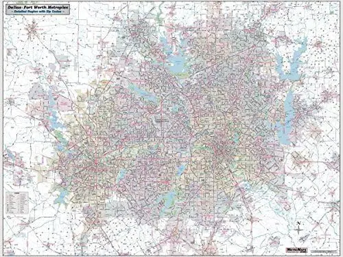
Updated – Sharp and functional map published by Metro Maps, sold and distributed by Wide World Maps & MORE! This jumbo 64″ × 48″ wall map offers the best of both worlds with a unique combination of detail and coverage that cannot be imitated by internet or app maps. Extensive coverage includes all of Dallas and Tarrant Counties, as well as the booming communities of Collin, Denton, and other adjacent counties. From Melissa to Midlothian and Rockwall to Lake Weatherford, this map covers the Metroplex and beyond! Comprehensive detail showing every street, with all major roads labeled – including ‘Farm to Market’ county designations. All toll roads, airports, passenger and freight rail lines, hospitals, colleges, parks, high schools, major points of interest, rivers, major terrain features, and current ZIP codes are all clearly indicated. Gloss laminated, this large wall map is ideal for dry-erase markups.
Ready-to-Hang maps have rails at the top and the bottom to keep the map flat against the wall with two loops on the top rail for easy hanging. A package of wall hooks and nails completes the set.
- Ready-to-hang, dry-erase laminated, one-sided, jumbo wall map.
- Size: 64″ × 48″
Explore more from our collection.

![Dike Tank 7.5' Arizona 1980 [Map] United Stated Geological Survey 1](https://carpartsvault.shop/wp-content/uploads/2026/05/410Z8JECelL._SL1000_ff8cf6a6-59ba-4b88-b5f2-991ca26dc2b6-5zS0Jb.tmp_.webp)
![Dome Rock Mts Sw, Arizona 7.5' [Map] United Stated Geological Survey 1](https://carpartsvault.shop/wp-content/uploads/2026/05/419-VJ68DR.tmp_.webp)
Reviews
There are no reviews yet.