Description
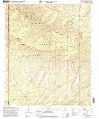
Baldy Bill Point, AZ 1997 USGS 7.5-minute topographic quadrangle map
- Product Details
- Product Number: 42525
- Scale: 1:24,000
- Content: Contours
- Alternate ID: TAZ2123
- ISBN: 978-0-607-95589-7
- Version Date: 01/01/1997
- Regions: AZ
- Countries: USA
- Latitude: 33° 37′ 30″ N to 33° 30′ 0″ N
- Longitude: 109° 30′ 0″ W to 109° 22′ 30″ W
- Media: Paper
- Format: Flat
- Historical Reproduction: Yes
- Additional Details
- Description: United States Geological Survey Baldy Bill Point, Arizona Historical Map Reprint 7.5×7.5 Grid 24000-Scale 1997
- Survey Date: 1997
- Print Date: 2000
- Height In Inches: 26.700
- Length In Inches: 22.000
- Boundary Type: Quadrangle
- UTM Grid: Ticks
- Horizontal Datum: North American 1983; North American 1927
- Vertical Datum: National Geodetic 1929
- UTM: Zone 12
- Two-Sided: No
- Plates: 1
- Pieces: 1
- Languages: English
Explore more from our collection.
![Dome Rock Mts Sw, Arizona 7.5' [Map] United Stated Geological Survey 1](https://carpartsvault.shop/wp-content/uploads/2026/05/419-VJ68DR.tmp_.webp)


Reviews
There are no reviews yet.