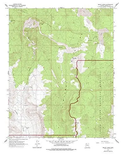
Description
USGS 7.5-minute topographic quadrangle map
- Scale: 1:24,000
- Content: Contours
- Alternate ID: TAZ0949
- ISBN: 978-0-607-06911-2
- Regions: AZ
- Nations: USA
- Latitude: 36° 15′ 0″ N to 36° 22′ 30″ N
- Longitude: 113° 15′ 0″ W to 113° 7′ 30″ W
- Media: Paper
- Format: Flat
- Description: Mount Logan, AZ Historical Map 7.5’×7.5′ Grid 24000-Scale 1977
- Survey Date: 1967
- Print Date: 1977
- Height In Inches: 27.000
- Width In Inches: 21.750
- Boundary Type: Quadrangle
- Two Sided: No
- Plates: 1
- Pieces: 1
- Languages: English
Explore more from our collection.
![Dike Tank 7.5' Arizona 1980 [Map] United Stated Geological Survey 1](https://carpartsvault.shop/wp-content/uploads/2026/05/410Z8JECelL._SL1000_ff8cf6a6-59ba-4b88-b5f2-991ca26dc2b6-5zS0Jb.tmp_.webp)
![Apache Maid Mountain, Arizona 7.5' [Map] United States Geological Survey 1](https://carpartsvault.shop/wp-content/uploads/2026/05/410Z8JECelL._SL1000_dce0475b-5bbc-42d7-84d0-78eeff0231e4-2aslbs.tmp_.webp)
![Ecuador, Quito, Guayaquil, Galapagos [Map] Pham Viet Hoa And Kevin Healey 1](https://carpartsvault.shop/wp-content/uploads/2026/05/41hS5ABEG-L._SL1000-lEpnia.tmp_.webp)
Reviews
There are no reviews yet.