Description
- Product Details
- Product Number: 112765D
- Scale: 1:4,000,000
- Alternate ID: 112765DLAM
- ISBN: 978-0-607-98432-3
- Version Date: 01/01/1992
- Countries: USA
- Media: Dry Erase Laminated Paper
- Format: Flat
- Additional Details
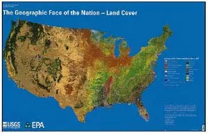
- Description: Use this United States Geological Survey map of land cover of the conterminous USA to teach and learn about the extent and distribution of cropland, scrub, forests, urban areas, grassland, and other land cover types, as well as the relationship of land cover to climate, to population distribution, to latitude, and to elevation. Dry Erase Lamination is specialty laminate that allows for dry erase markers to be used on the finished print and erased as desired.
- Map measures 56″×36″.
- Survey Date: 1992
- Print Date: 2002
- Height In Inches: 35.000
- Length In Inches: 54.750
- Boundary Type: Political Unit
Explore more from our collection.
![Arizona's White Mountains [Map] Russel Mead 1](https://carpartsvault.shop/wp-content/uploads/2026/05/51Yr21jVcsL._SL1000-9RhxEj.tmp_.webp)
![Baja Peninsula Infared From Space Satellite Map Gloss Laminated [Map] Spaceshots Inc. 1](https://carpartsvault.shop/wp-content/uploads/2026/05/41DKYrRbd2L._SL1000_804c6dca-6d63-4e78-ba5f-aedfab787fff-h4Bc68.tmp_.webp)

Reviews
There are no reviews yet.