
Description
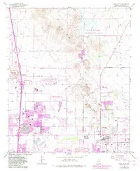
Union Hills, AZ 1964 PR 1981 USGS 7.5-minute topo quad map
- Product Details
- Product Number: 41966
- Scale: 1:24,000
- Alternate ID: TAZ1526
- ISBN: 978-0-607-07331-7
- Version Date: 01/01/1981
- Region: AZ
- Country: USA
- Latitude: 33° 45′ 00″ N to 33° 37′ 30″ N
- Longitude: 112° 07′ 30″ W to 112° 00′ 00″ W
- Media: Paper
- Format: Folded
- Historical Reproduction: Yes
- Additional Details
- Description: United States Geological Survey Union Hills, Arizona Historical Reprint Map 7.5’×7.5′ Grid 24000-Scale 1964 Photorevised 1981
- Survey Date: 1981
- Print Date: 1983
- Height In Inches: 27.000
- Length In Inches: 22.000
- Boundary Type: Quadrangle
- UTM Grid: Grid Lines
- Horizontal Datum: North American 1927 (NAD27); North American 1983 (NAD83)
- Vertical Datum: National Geodetic 1929
- UTM: Zone 12
- Two-Sided: No
- Plates: 1
- Pieces: 1
- Languages: English
Explore more from our collection.
![Douglas Ne 7.5', Arizona [Map] United Stated Geological Survey 1](https://carpartsvault.shop/wp-content/uploads/2026/05/410Z8JECelL._SL1000_960643bf-125f-462b-8727-48bf6bdc1077-1K0TR9.tmp_.webp)
![Arizona's White Mountains [Map] Russel Mead 1](https://carpartsvault.shop/wp-content/uploads/2026/05/51Yr21jVcsL._SL1000-9RhxEj.tmp_.webp)
![Estado De Baja California Sur [Map] Guia Roji 1](https://carpartsvault.shop/wp-content/uploads/2026/05/51NXwO-_2BFSL._SL1000-rHEoCx.tmp_.webp)
Reviews
There are no reviews yet.