Description
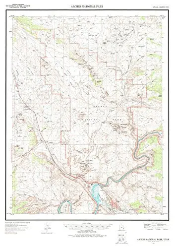
United States Department of the Interior Geological Survey‘s Arches National Park, Utah is a political, road, topographic, and recreation map all-in-one! The legend includes primary highways with hard surfaces, secondary highways with hard surfaces, light duty roads with either hard or improved surfaces, interstate routes, U. S. routes, and state routes. Paper, one-sided wall map. Scale = 1:50,000; Projection = Lambert Conformal Conic; 10,000′ Grid Ticks = Utah Coordinate System, Central Zone; 5,000m Grid Ticks = UTM Zone 12; Horizontal Datum = North American 1927; Vertical Datum = National Geodetic 1929; Contour Interval = 80′ topographic; Supplemental Contour Interval = 40′ topographic; Size = 34″ x 25″; Latitude = 33° 30′ 0″ N to 38° 52′ 0″ N; Longitude = 109° 45′ 0″ W to 109° 27′ 0″ W
Explore more from our collection.

![Dike Tank 7.5' Arizona 1980 [Map] United Stated Geological Survey 1](https://carpartsvault.shop/wp-content/uploads/2026/05/410Z8JECelL._SL1000_ff8cf6a6-59ba-4b88-b5f2-991ca26dc2b6-5zS0Jb.tmp_.webp)

Reviews
There are no reviews yet.