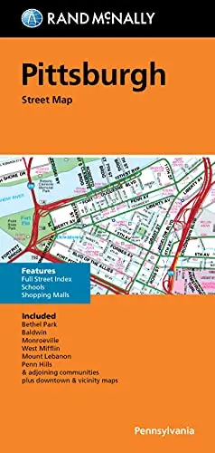
Description
Rand McNally‘s folded map for Pittsburgh is a must-have for anyone traveling in and around this part of Pennsylvania, offering unbeatable accuracy and reliability at a great price. Our trusted cartography shows all Interstate, U.S., state, and county highways, along with clearly indicated parks, points of interest, airports, county boundaries, and streets. The easy-to-use legend and detailed index make for quick and easy location of destinations. You’ll see why Rand McNally folded maps have been the trusted standard for years.
- Regularly updated.
- Full-color maps.
- Clearly labeled Interstate, U.S., state, and county highways.
- Indications of parks, points of interest, airports, county boundaries, schools, shopping malls, downtown & vicinity maps.
- Easy-to-use legend.
- Detailed index & full street index.
- Convenient folded size.
- Coverage Area Communities included, Bethel Park, Baldwin, Monroeville, West Mifflin, Mount Lebanon, Penn Hills & adjoining communities.
- Product Details: Measures 4.5′ × 9′ and folds out to 40′ × 28′.
Explore more from our collection.

![Douglas Ne 7.5', Arizona [Map] United Stated Geological Survey 1](https://carpartsvault.shop/wp-content/uploads/2026/05/410Z8JECelL._SL1000_960643bf-125f-462b-8727-48bf6bdc1077-1K0TR9.tmp_.webp)
![Baja Peninsula Infared From Space Satellite Map Gloss Laminated [Map] Spaceshots Inc. 1](https://carpartsvault.shop/wp-content/uploads/2026/05/41DKYrRbd2L._SL1000_804c6dca-6d63-4e78-ba5f-aedfab787fff-h4Bc68.tmp_.webp)
Reviews
There are no reviews yet.