Description
Fish-n-Map Company produces bathymetric fishing maps useful to fishermen, boaters, and campers. Featuring GPS locations, these are convenient fishing maps that last!
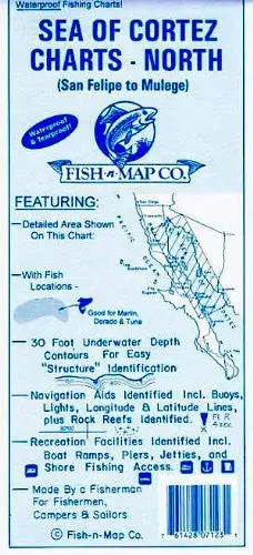
Fish-n-Map Company‘s underwater topography maps are printed on a water-proof, tear-resistant plastic material for durability in the field and are folded to 4″ x 9″. When opened, the maps are approximately 3′ x 2’ in size and printed on both sides.
Fish-n-Map Company‘s maps include extensive and detailed legends that guide you through valuable information such as;
* Gulf of California Fishing Strategy
* Known Fish Species
* Underwater Bottom Conditions
* Depth Contours
* Boat Ramp Locations
* River Inlets, Feeder Creeks & Canals
* Submerged Brush & Rock Reefs
* Longitude & Latitude Grid
* Campgrounds & Restrooms
* Lodging, Groceries, & Fuel
* RV Hook-ups, Showers, & Lodging
* Suggested Fishing Locations
* and more…
These maps will not only improve your fishing trip, but your entire outdoor experience.
Two-sided, self-cover, waterproof folded map.
Scale:
* Sea of Cortez (North) = 1:680,213
* Santa Rosalia to Mulegé = 1:159,176
* Bahia de los Angeles = 1:43,480
* Las Islas Encantadas = 1:232.5k
* Guaymas = 1:48.7k
* Puerto Refugio = 1:32.8k
* Bahia San Francisquito = 1:32,702
Contours = 30′
Water Type: Salt
Size:
* Folded = 4″ x 9″
* Unfolded = 36″ x 24″
Explore more from our collection.

![Dome Rock Mts Sw, Arizona 7.5' [Map] United Stated Geological Survey 1](https://carpartsvault.shop/wp-content/uploads/2026/05/419-VJ68DR.tmp_.webp)

Reviews
There are no reviews yet.