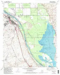
Description
Needles, CA-AZ, 1970 PR 1975 USGS 7.5-minute topo quad map
- Product Details
- Product Number: 44846
- Scale: 1:24,000
- Content: Contours
- Alternate ID: TCA1644
- ISBN: 978-0-607-62294-2
- Version Date: 01/01/1975
- Regions: AZ, CA
- Countries: USA
- Latitude: 34° 52′ 30″ N to 34° 45′ 00″ N
- Longitude: 114° 37′ 30″ W to 114° 30′ 00″ W
- Media: Paper
- Format: Flat
- Historical Reproduction: Yes
- Additional Details
- Description: United States Geological Survey Needles, California-Arizona Historical Map Reprint 7.5×7.5 Grid 24000-Scale 1970 Photorevised 1975
- Survey Date: 1970
- Print Date: 1977
- Height In Inches: 26.800
- Length In Inches: 21.500
- Boundary Type: Quadrangle
- UTM Grid: Ticks
- Horizontal Datum: North American 1927
- Vertical Datum: National Geodetic 1929
- UTM: Zone 11
- Two-Sided: No
- Plates: 1
- Pieces: 1
- Languages: English
Explore more from our collection.
![Estado De Baja California Sur [Map] Guia Roji 1](https://carpartsvault.shop/wp-content/uploads/2026/05/51NXwO-_2BFSL._SL1000-rHEoCx.tmp_.webp)
![Ecuador, Quito, Guayaquil, Galapagos [Map] Pham Viet Hoa And Kevin Healey 1](https://carpartsvault.shop/wp-content/uploads/2026/05/41hS5ABEG-L._SL1000-lEpnia.tmp_.webp)
![Arizona's White Mountains [Map] Russel Mead 1](https://carpartsvault.shop/wp-content/uploads/2026/05/51Yr21jVcsL._SL1000-9RhxEj.tmp_.webp)
Reviews
There are no reviews yet.