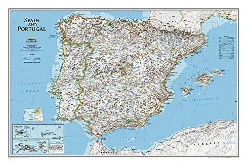
Description
The signature Classic style wall map of Spain and Portugal features a bright color palette with blue oceans and the Iberian Peninsula’s terrain detailed in stunning shaded relief that has been a hallmark of National Geographic wall maps for over 75 years. The map includes thousands of place names, accurate boundaries, national parks, and major infrastructure networks such as roads, highways, airports, ferry routes, and railroads. Coastal bathymetry is shown with depth curves and soundings. Spain’s Balearic Islands in the Mediterranean are included. Inset maps provide detail of the Madeira Islands, Azores, and Canary Islands, as well as their location in relation to Spain and Portugal.
The map is encapsulated in heavy-duty 1.6 mil laminate, which makes the paper much more durable and resistant to the swelling and shrinking caused by changes in humidity. Laminated maps can be framed without the need for glass, so the frames can be much lighter and less expensive. Dry-Erase Lamination is a specialty laminate that allows for dry-erase markers to be used on the finished print and erased as desired. The dry erase laminated map is a convenient and useful at-a-glance reference ready for wet-erase or alcohol-erase markers, sticker dots or arrows, or graphic tape.
- Dry erase laminated, one-sided wall map.
- Map Scale = 1:2,075,000
- Sheet Size = 33″ × 22″
Explore more from our collection.
![Mexico Central Map By Guia Roji (Bilingual) (Spanish Edition) (English And Spanish Edition) [Map] Guia Roji 1](https://carpartsvault.shop/wp-content/uploads/2026/05/5196CDNB7GL._SL1000-t007Bz.tmp_.webp)
![Apache Maid Mountain, Arizona 7.5' [Map] United States Geological Survey 1](https://carpartsvault.shop/wp-content/uploads/2026/05/410Z8JECelL._SL1000_dce0475b-5bbc-42d7-84d0-78eeff0231e4-2aslbs.tmp_.webp)

Reviews
There are no reviews yet.