Description
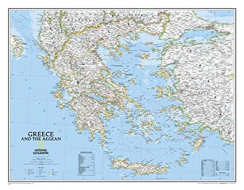
National Geographic‘s wall map of Greece and the Aegean is one of the largest and most detailed maps of the area. The signature Classic style design uses a bright, easy-to-read color palette and stunning shaded relief. Coverage includes mainland Greece along with areas of bordering Albania, Macedonia, Bulgaria, and Turkey. Surrounding waterways, like the Aegean and Ionian Seas, are shown with depth curves and soundings along with hundreds of islands, including Crete, Rhodes, and Euboea. Also shown are thousands of place names, accurate boundaries, national parks, ruins, and major infrastructure networks such as roads, highways, airports, railroads, canals, and ferry routes.
The map is encapsulated in heavy-duty 1.6 mil laminate which makes the paper much more durable and resistant to the swelling and shrinking caused by changes in humidity. Laminated maps can be framed without the need for glass, so the frames can be much lighter and less expensive. Dry Erase Lamination is a specialty laminate that allows for dry erase markers to be used on the finished print and erased as desired.
- One-sided, dry-erase laminated wall map
- Flat Size — 30.25″ × 23.5″
- Scale — 1:1,494,000
Explore more from our collection.
![Dike Tank 7.5' Arizona 1980 [Map] United Stated Geological Survey 1](https://carpartsvault.shop/wp-content/uploads/2026/05/410Z8JECelL._SL1000_ff8cf6a6-59ba-4b88-b5f2-991ca26dc2b6-5zS0Jb.tmp_.webp)
![Baja Peninsula Infared From Space Satellite Map Gloss Laminated [Map] Spaceshots Inc. 1](https://carpartsvault.shop/wp-content/uploads/2026/05/41DKYrRbd2L._SL1000_804c6dca-6d63-4e78-ba5f-aedfab787fff-h4Bc68.tmp_.webp)

Reviews
There are no reviews yet.