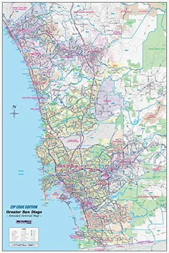
Description
Sharp, functional wall map of Greater San Diego from Wide World Maps & MORE!, featuring original artwork and cartography by Metro Maps. Modern data, including ZIP codes, shows all streets, all major points of interest, detailed transit routes, and highway connections. Please take a look at the samples for a full indication of map quality.
This wall map offers the best of both worlds, combining detail and coverage. From Oceanside to the Mexico border and Ramona to La Jolla – the entire San Diego region is covered. Every street is shown, with all major roads labeled. Freeways (with exit numbers), toll roads, airports, commuter rail lines, hospitals, colleges, parks, high schools, major points of interest, rivers, and major terrain features are all clearly indicated.
Ideal for the office, warehouse, classroom, or home. Laminated and ready to ship!
- Gloss laminated, one-sided, small 24″×36″, portrait-oriented wall map
Explore more from our collection.
![Ecuador, Quito, Guayaquil, Galapagos [Map] Pham Viet Hoa And Kevin Healey 1](https://carpartsvault.shop/wp-content/uploads/2026/05/41hS5ABEG-L._SL1000-lEpnia.tmp_.webp)


Reviews
There are no reviews yet.