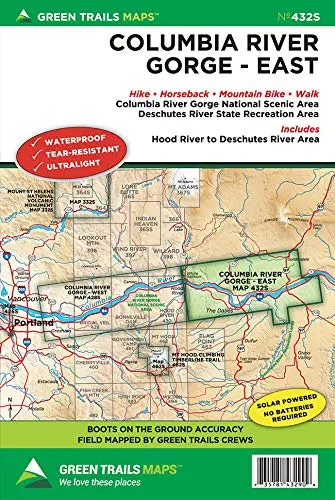
Description
Discover the wide array of trails in the Gorge’s eastern sunnier and drier reaches where waterfalls succumb to golden hillsides of resplendent wildflowers and impressive basaltic canyons. This special series map covers the Columbia River Gorge National Scenic Area from Hood River and White Salmon east to the Deschutes River and Maryhill. Map also includes detailed insets of some of the Eastern Gorge’s best mountain biking areas; the Coyote Wall, Catherine Creek and Deschutes State Park. You’ll also find the entire 31 mile long Klickitat Trail, Columbia Hills trail network, and The Dalles’ Waterfront Trail on this map.
Relied upon for more than 50 years by hikers, climbers, backpackers, backcountry skiers, snowshoers, and more. Green Trails Maps include*:
- Trails coded for hikers only, hikers and bikes, horses, X-C skiers, snowmobiles
- Icons for picnic areas, tent camping, RV spaces, bathrooms, and backcountry toilets
- Icons for points of interest, waterfalls, springs, gates, parking areas
- Dot-to-dot trail distances, contour intervals, adjacent map numbers, permits required
- Land designations such as national and state parks, national forest wilderness, DNR land, private land, Indian reservations
Explore more from our collection.
![Mexico Mapa De Carreteras [Paperback] Varios 1](https://carpartsvault.shop/wp-content/uploads/2026/05/51tf9UzB5fL._SL1000-92Yl7n.tmp_.webp)


Reviews
There are no reviews yet.