Description
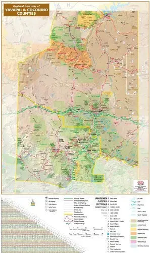
Regional Area Map of Yavapai & Coconino Counties is a shaded relief wall map of Yavapai and Coconino Counties, Arizona, USA. The map includes national scenic byways, scenic roadways, a milage chart, scale bars in miles and kilometers, and a complete legend.
The legend features numbered interstate highways, US highways, state highways, Indian highways, and non-Arizona state highways; routed interstate highways, principal paved highways, other paved highways, graded maintained roadways, and gravel roadways; traffic interchanges; interchange exit numbers; state boundaries and county boundaries; the Arizona Trail, national scenic byways, and scenic roadways; point-to-point distances in miles; tribal headquarters; county seats; municipalities by population ranges; public and private airports, major airports, and military airports; campsites, information centers, mountain peaks, points of interest, roadside rest areas, ski areas, and 24 hour emergency services; dry lakes, lakes, major rivers, rivers, streams and washes, and canals and aqueducts; and surface management for Indian reservations and communities, national forests, national monuments, national parks, wilderness areas, wildlife refuges, and US military facilities.
- Su Ling Heydrich
Explore more from our collection.
![Douglas Ne 7.5', Arizona [Map] United Stated Geological Survey 1](https://carpartsvault.shop/wp-content/uploads/2026/05/410Z8JECelL._SL1000_960643bf-125f-462b-8727-48bf6bdc1077-1K0TR9.tmp_.webp)
![Mexico Central Map By Guia Roji (Bilingual) (Spanish Edition) (English And Spanish Edition) [Map] Guia Roji 1](https://carpartsvault.shop/wp-content/uploads/2026/05/5196CDNB7GL._SL1000-t007Bz.tmp_.webp)

Reviews
There are no reviews yet.