Description
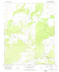
Eagle Nest Mtn, AZ 1973 USGS 7.5-minute topo quad map
- Product Details
- Product Number: 40894
- Scale: 1:24,000
- Content: Contours
- Alternate ID: TAZ0449
- ISBN: 978-0-607-06537-4
- Version Date: 01/01/1973
- Regions: AZ
- Countries: USA
- Latitude: 35° 30′ 00″ N to 35° 22′ 30″ N
- Longitude: 112° 37′ 30″ W to 112° 30′ 00″ W
- Media: Paper
- Format: Flat
- Historical Reproduction: Yes
- Additional Details
- Description: United States Geological Survey Eagle Nest Mountain, Arizona Historical Map Reprint 7.5×7.5 Grid 24000-Scale 1973
- Survey Date: 1973
- Print Date: 1976
- Height In Inches: 26.800
- Length In Inches: 22.000
- Boundary Type: Quadrangle
- UTM Grid: Ticks
- Horizontal Datum: North American 1927
- Vertical Datum: National Geodetic 1929
- UTM: Zone 12
- Two-Sided: No
- Plates: 1
- Pieces: 1
- Languages: English
Explore more from our collection.


Reviews
There are no reviews yet.