Description
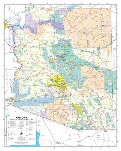
Phoenix Mapping Service Arizona Highways and Roads Small Wall Map, Gloss Laminated is a State of Arizona color wall map detailing highways and roads in a small 24″ × 30″ size.
This detailed and up-to-date gloss laminated wall map shows all of the interstate, state, and tribal highway systems of Arizona and is ready for erasable markers. Also included are cities and towns with relevant population information; townships by township and range grid; rivers, streams, lakes, and mountain ranges; counties, and Native American tribal lands, military reservations, wilderness areas, wildlife refuges, and National Parks, Forests, and Monuments.
Gloss Lamination features premium optically clear film which provides a high shine for dramatic color presentation. The gloss laminated map is a convenient and useful at-a-glance reference ready for wet erase or alcohol erase markers, sticker dots or arrows, or graphic tape.
- Gloss laminated paper, one-sided wall map.
- Size: 24″ × 30″
Explore more from our collection.
![Douglas Ne 7.5', Arizona [Map] United Stated Geological Survey 1](https://carpartsvault.shop/wp-content/uploads/2026/05/410Z8JECelL._SL1000_960643bf-125f-462b-8727-48bf6bdc1077-1K0TR9.tmp_.webp)
![Dome Rock Mts Sw, Arizona 7.5' [Map] United Stated Geological Survey 1](https://carpartsvault.shop/wp-content/uploads/2026/05/419-VJ68DR.tmp_.webp)
![Mexico Central Map By Guia Roji (Bilingual) (Spanish Edition) (English And Spanish Edition) [Map] Guia Roji 1](https://carpartsvault.shop/wp-content/uploads/2026/05/5196CDNB7GL._SL1000-t007Bz.tmp_.webp)
Reviews
There are no reviews yet.