Description
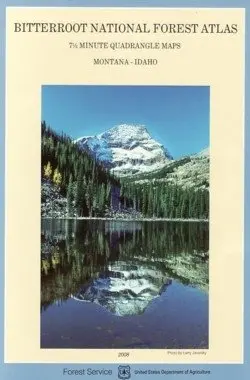
Description: This 8 ½ X 11 inch atlas depicts 86 USGS quadrangles in and around Bitterroot National Forest at 63,360 scale, so 1 inch represents 1 mile. All maps were revised in accordance with aerial photographs taken in 1995. Land ownership is color-coded to reflect private and public holdings. A contour interval of 100 feet appears on every map, UTM tick marks are spaced at 1,000 meter intervals, and all maps are cast on the NAD83 horizontal datum. A lookup chart at the beginning and end of the atlas provides an overview of the 86 quadrangle locations. The Nez Perce and Lewis & Clark Historical Trails are shown, as well as recreational landmarks such as trailheads, ranger stations, restroom facilities, and points-of-interest. This atlas is a compact, durable reference guide for the outdoor recreationist. Survey Date: 2008
Explore more from our collection.
![South America Southern 1:2,600,000 Travel Map [Map] Itmb Canada 1](https://carpartsvault.shop/wp-content/uploads/2026/05/41kisHCDzcL._SL1000-vqnKLq.tmp_.webp)
![Hourglass Nebula Poster Gloss Laminated [Wall Chart] R. Sahai And J. Trauger 1](https://carpartsvault.shop/wp-content/uploads/2026/05/41jmHg3bJtL._SL1000-5wbaCZ.tmp_.webp)
Reviews
There are no reviews yet.