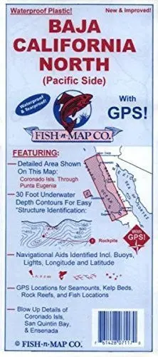
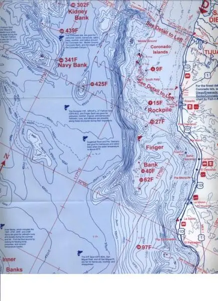
Description
Waterproof fishing and boating map with GPS coordinate and more
- Contours: 30′
- Scale: 1:350,000 / Ensenada 1:83,300 / San Quentin 1:107,100 / Coronado Isl 1:26,700
- GPS Data: Yes
- Water Type: Salt
- Region/State(s): Southern California, Mexico
- UPC: 761428 071170
- Two-sided, self-cover, plastic folded map
Explore more from our collection.
Quality Baja California North (Pacific Side) for your collection.
![Baja Peninsula Infared From Space Satellite Map Gloss Laminated [Map] Spaceshots Inc. 1](https://carpartsvault.shop/wp-content/uploads/2026/05/41DKYrRbd2L._SL1000_804c6dca-6d63-4e78-ba5f-aedfab787fff-h4Bc68.tmp_.webp)
![Dike Tank 7.5' Arizona 1980 [Map] United Stated Geological Survey 1](https://carpartsvault.shop/wp-content/uploads/2026/05/410Z8JECelL._SL1000_ff8cf6a6-59ba-4b88-b5f2-991ca26dc2b6-5zS0Jb.tmp_.webp)
![Douglas Ne 7.5', Arizona [Map] United Stated Geological Survey 1](https://carpartsvault.shop/wp-content/uploads/2026/05/410Z8JECelL._SL1000_960643bf-125f-462b-8727-48bf6bdc1077-1K0TR9.tmp_.webp)
Reviews
There are no reviews yet.