
Description
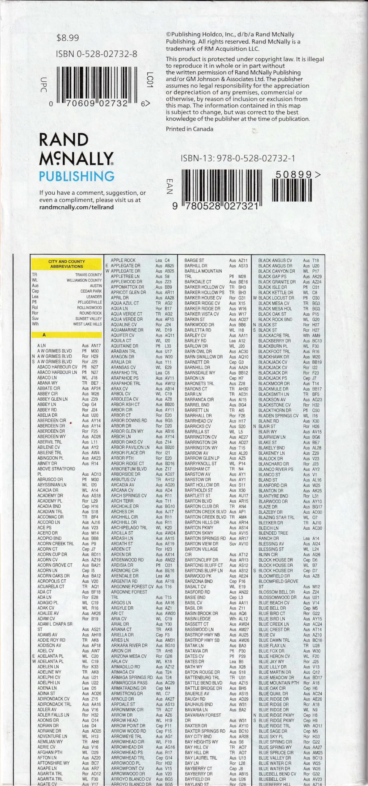
Rand McNally‘s folded map for Austin is a must-have for anyone traveling in and around this part of Texas, offering unbeatable accuracy and reliability at a great price. Our trusted cartography shows all Interstate, U.S., state, and county highways, along with clearly indicated parks, points of interest, airports, county boundaries, and streets. The easy-to-use legend and detailed index make for quick and easy location of destinations. You’ll see why Rand McNally folded maps have been the trusted standard for years.
- Description
- Regularly updated
- Full-color maps
- Clearly labeled Interstate, U.S., state, and county highways
- Indications of parks, points of interest, airports, county boundaries, schools, shopping malls, downtown & vicinity maps
- Easy-to-use legend
- Detailed & full street index
- Convenient folded size
- Copyright 2023
- Coverage Area
- Communities Included: Cedar Park, Leander*, Pflugerville*, Rollingwood, Round Rock*, Sunset Valley, West Lake Hills, and downtown enlargement.
(*denotes partial coverage)
- Communities Included: Cedar Park, Leander*, Pflugerville*, Rollingwood, Round Rock*, Sunset Valley, West Lake Hills, and downtown enlargement.
- Product Details
- Measures 4″ × 9.5″ and folds out to 28″ × 40″.
- Two-sided, self-cover, paper/non-laminated folded map.
- Additional Information
- SKU: 0528027328
- UPC: 070609027326
- ISBN: 9780528027321
- Folded Maps: City/Street
Explore more from our collection.
![Mexico Mapa De Carreteras [Paperback] Varios 1](https://carpartsvault.shop/wp-content/uploads/2026/05/51tf9UzB5fL._SL1000-92Yl7n.tmp_.webp)

![Mexico Central Map By Guia Roji (Bilingual) (Spanish Edition) (English And Spanish Edition) [Map] Guia Roji 1](https://carpartsvault.shop/wp-content/uploads/2026/05/5196CDNB7GL._SL1000-t007Bz.tmp_.webp)
Reviews
There are no reviews yet.