Description
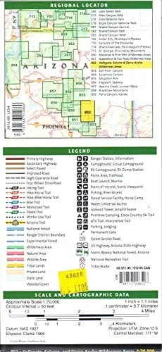
This regional map features primary highways, secondary highways, select paved roads, improved roads, high clearance roads, four wheel drive roads, hiking trails, hike/horse trails, hike/bike/horse trails, bike trails, motorized trails, paved trails, winter use trails, the Arizona Trail, national forest boundaries, ranger district boundaries, experimental forest boundaries, wilderness area boundaries, natural area boundaries, wildlife area boundaries, tribal lands boundaries, private land shading, state land shading, wooded cover shading, ranger stations, information stations, campgrounds, group campgrounds, RV campgrounds, RV dump stations, picnic areas, trailheads, boat launches, marinas, points of interest, scenic viewpoints, fishing spots, river access spots, forest service facility, horse camps, water stations, universal access points, lookout towers, amphitheaters, primitive camping spots, cross country ski trails, ATV trails, interpretive trails, parking, lodging, permanent gates, forest service roads, US highways, Arizona state highways, National Forest Scenic Byways, Arizona Scenic Byways, National Recreation Trails, and tribal routes.
- Two-sided, self-cover, plastic folded map
Explore more from our collection.

![Apache Maid Mountain, Arizona 7.5' [Map] United States Geological Survey 1](https://carpartsvault.shop/wp-content/uploads/2026/05/410Z8JECelL._SL1000_dce0475b-5bbc-42d7-84d0-78eeff0231e4-2aslbs.tmp_.webp)
![Baja Peninsula Infared From Space Satellite Map Gloss Laminated [Map] Spaceshots Inc. 1](https://carpartsvault.shop/wp-content/uploads/2026/05/41DKYrRbd2L._SL1000_804c6dca-6d63-4e78-ba5f-aedfab787fff-h4Bc68.tmp_.webp)
Reviews
There are no reviews yet.