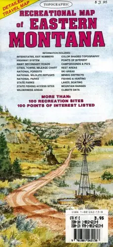
Description
The topographic full color map of Eastern Montana is scaled at 1″ = 12.5 miles. Elevation contours every 1,000 feet (color-shaded every 2,000 feet at higher elevations) portray the general geography. Also shown are national forests, wilderness areas, campgrounds, parks, state game and fish areas, ski areas, mining districts, points of interest, and more. More roads are shown than on typical highway maps. Much printed textual information is also included.
- Two-sided, self-cover, paper folded map
- 47906-1995ed
Explore more from our collection.
![Estado De Baja California Sur [Map] Guia Roji 1](https://carpartsvault.shop/wp-content/uploads/2026/05/51NXwO-_2BFSL._SL1000-rHEoCx.tmp_.webp)

![Douglas Ne 7.5', Arizona [Map] United Stated Geological Survey 1](https://carpartsvault.shop/wp-content/uploads/2026/05/410Z8JECelL._SL1000_960643bf-125f-462b-8727-48bf6bdc1077-1K0TR9.tmp_.webp)
Reviews
There are no reviews yet.