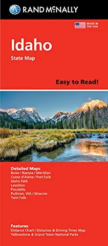
Description
Rand McNally‘s Easy To Read! State Folded Map is a must-have for anyone traveling in and around Idaho, offering unbeatable accuracy and reliability at a great price. Our trusted cartography shows all Interstate, U.S., state, and county highways, along with clearly indicated parks, points of interest, airports, county boundaries, and streets. The easy-to-use legend and detailed index make for quick and easy location of destinations. You’ll see why Rand McNally folded maps have been the trusted standard for years.
- Regularly updated, full-color maps.
- 128% larger map with a bigger type size than the Rand McNally Folded Map.
- Clearly labeled Interstate, U.S., state, and county highways.
- Indications of parks, points of interest, airports, county boundaries, and more.
- Mileage and driving times map.
- Detailed index.
- Convenient folded size.
- Coverage Area Detailed Maps of Boise/Nampa/Meridian, Coeur dAlene, Idaho Falls, Lewiston, Pocatello, Twin Falls, and Yellowstone & Grand Teton National Parks.
- Product Details Dimensions (unfolded): 40″ × 28″.
Explore more from our collection.
![Estado De Baja California Sur [Map] Guia Roji 1](https://carpartsvault.shop/wp-content/uploads/2026/05/51NXwO-_2BFSL._SL1000-rHEoCx.tmp_.webp)
![Dino's Quiz Map Of The Solar System [Map] Dino Kalogjera And Sanja Kolaj 1](https://carpartsvault.shop/wp-content/uploads/2026/05/61n5FQ5hDBL._SL1000-TSWDOh.tmp_.webp)
![Dike Tank 7.5' Arizona 1980 [Map] United Stated Geological Survey 1](https://carpartsvault.shop/wp-content/uploads/2026/05/410Z8JECelL._SL1000_ff8cf6a6-59ba-4b88-b5f2-991ca26dc2b6-5zS0Jb.tmp_.webp)
Reviews
There are no reviews yet.