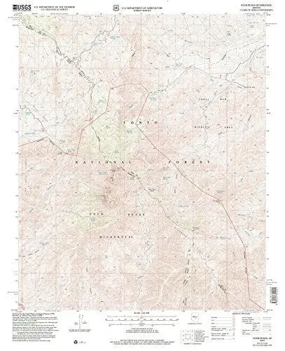
Description
- Product Details
- Long Name: Four Pks, AZ 2004 USGS 7.5-minute topo quad map
- Scale: 1:24,000
- Content: Contours
- Alternate ID: TAZ0509
- ISBN: 978-1-4113-1422-1
- Version Date: 2004
- Regions: AZ
- Countries: USA
- Latitude: 33° 37′ 30″ N to 33° 45′ 0″ N
- Longitude: 111° 22′ 30″ W to 111° 15′ 0″ W
- Media: Paper
- Format: Flat
- Historical Reproduction: Yes
- Additional Details
- Description: United States Geological Survey Four Peaks, Arizona Historical Reprint Map 7.5×7.5 Grid 24000-Scale 2004
- Survey Date: 1978, 2004
- Print Date: 1992, 2007
- Height In Inches: 27.000
- Width In Inches: 22.000
- Boundary Type: Quadrangle
- UTM Grid: Grid
- Horizontal Datum: NORTH AMERICAN 1927; NORTH AMERICAN 1983
- Vertical Datum: NATIONAL GEODETIC 1929
- UTM: Zone 12
- Two-Sided: No
- Plates: 1
- Pieces: 1
- Languages: English
Explore more from our collection.
![Mexico Central Map By Guia Roji (Bilingual) (Spanish Edition) (English And Spanish Edition) [Map] Guia Roji 1](https://carpartsvault.shop/wp-content/uploads/2026/05/5196CDNB7GL._SL1000-t007Bz.tmp_.webp)
![Dike Tank 7.5' Arizona 1980 [Map] United Stated Geological Survey 1](https://carpartsvault.shop/wp-content/uploads/2026/05/410Z8JECelL._SL1000_ff8cf6a6-59ba-4b88-b5f2-991ca26dc2b6-5zS0Jb.tmp_.webp)

Reviews
There are no reviews yet.