Description
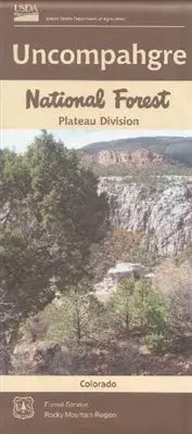
The Uncompahgre Plateau, located in western Colorado, was established as part of the Uncompahgre Forest Reserve by President Theodore Roosevelt’s proclamation of June 14, 1905. “Uncompahgre” is a Ute work describing “Rocks that make Water Red.” The Plateau itself is a long, narrow geologic uplift formation bordered on the east by the wide valleys of the Gunnison and Uncompahgre rivers and on the west by the narrow gorges of the Dolores and San Miguel rivers. Starting from an elevation of about 4600 feet, it rises to just under 10,000 feet.
- Year – 2016
- Scale – 1″ to the Mile (1:63,360)
- Topo Lines – No
- Shaded Relief – Yes
- Plastic – Type 2 High Density Polyethylene (HDPE) recyclable stock
- Region 2 – National Forest Service Rocky Mountain Region
Explore more from our collection.
![Mexico Central Map By Guia Roji (Bilingual) (Spanish Edition) (English And Spanish Edition) [Map] Guia Roji 1](https://carpartsvault.shop/wp-content/uploads/2026/05/5196CDNB7GL._SL1000-t007Bz.tmp_.webp)
![Dike Tank 7.5' Arizona 1980 [Map] United Stated Geological Survey 1](https://carpartsvault.shop/wp-content/uploads/2026/05/410Z8JECelL._SL1000_ff8cf6a6-59ba-4b88-b5f2-991ca26dc2b6-5zS0Jb.tmp_.webp)
![Mexico Mapa De Carreteras [Paperback] Varios 1](https://carpartsvault.shop/wp-content/uploads/2026/05/51tf9UzB5fL._SL1000-92Yl7n.tmp_.webp)
Reviews
There are no reviews yet.