
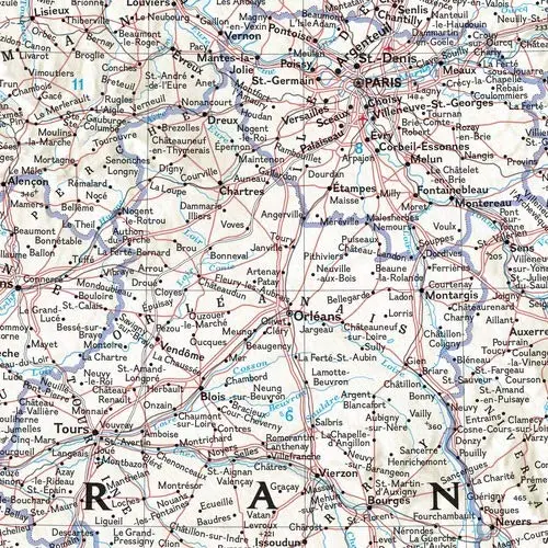
Description
Expertly researched and designed, National Geographic‘s Classic style political map of France, Belgium, and The Netherlands features clearly defined international boundaries, thousands of place names, waterbodies, airports, major highways and roads, national parks, and much more. Also shown are the region’s updated infrastructures, including major oil fields and pipelines; high-speed passenger railway lines; canals; and ferry routes. The tasteful color palette, shaded relief, and bathymetric data make this map as attractive as it is functional. Luxembourg and portions of the United Kingdom, Germany, Switzerland, Spain, and Italy are shown as well.
The map is packaged in a two inch diameter tube with a label showing a thumbnail of the map with dimensions and other pertinent information.
- Map Scale = 1:1,955,000
- Sheet Size = 23.5″ × 30.25″
Explore more from our collection.

![Mexico Central Map By Guia Roji (Bilingual) (Spanish Edition) (English And Spanish Edition) [Map] Guia Roji 1](https://carpartsvault.shop/wp-content/uploads/2026/05/5196CDNB7GL._SL1000-t007Bz.tmp_.webp)
![Dome Rock Mts Sw, Arizona 7.5' [Map] United Stated Geological Survey 1](https://carpartsvault.shop/wp-content/uploads/2026/05/419-VJ68DR.tmp_.webp)
Reviews
There are no reviews yet.